Greenwheels – Creating more livable towns with a car sharing app
The Netherlands may be known for its love affair with bicycles, but many people still rely on cars to get around, which means that the country is facing similar congestion and air pollution issues to the rest of the world. That’s what inspired Greenwheels to launch a car sharing service with a mission to “make cities more livable” by putting a fuel-efficient car around the corner from every Dutch home.

With Greenwheels, cars are parked a convenient walking distance from anybody in a town or city. Registered users open their vehicle with their smartphone or a public transport card and collect the key inside the glove compartment by entering a pin. They only pay for the miles they drive.
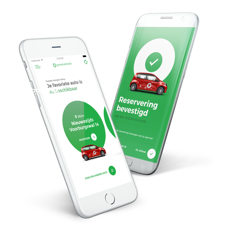
Four years ago, Greenwheels rebooted its dream of bringing back Dutch open spaces, with a new app powered by Google Maps Platform. Since then, an environmental mission that started 25 years ago has been picking up speed. A study by Dutch mobility consultancy Goudappel Coffeng shows that every new addition to the Greenwheels fleet takes 11 cars off the street. After joining Greenwheels, people drive an average of roughly 1,242 miles less per year, saving 16 tons of annual CO2 emissions for all customers.
“We’ve been in this business for a quarter of a century, and we see ourselves as pioneers of the global car sharing boom,” says Allard Hansma, Manager Marketing & Sales at Greenwheels. “Our app revamp, with a whole new customer experience powered by Google Maps Platform, marked the moment we saw a huge jump in our business and environmental performance.”
Making car sharing vehicles easier to find
A huge amount of thought goes into seemingly random placement of car sharing vehicles. We avoid, for example, positioning vehicles near bridges in Holland. Why? They’re always opening and closing to allow canal traffic, meaning customers can get stuck leaving or returning. Big trees are also to be avoided, to prevent the vehicle from being soiled by birds. In addition, Greenwheels seeks high-visibility locations. “Cars are our billboards, so these areas are prime advertising real estate,” Allard explains.
Allard calls such insights part of “a cocktail of experience” gained from more than 25 years in business. And Google Maps Platform, in particular the Maps Javascript API and the Maps Street View Service, are powerful enablers in leveraging this wealth of knowledge. The Maps Javascript API provides the big picture of vehicle placement, by dynamically layering landmarks such as thoroughfares and important buildings, says Allard. The Maps Street View Service, meanwhile, acts as the platform’s eyes on the street to spot trees and bridges and other real-life factors that determine its choices.
“We have an entire department devoted to finding ideal locations for stationing cars,” says Allard. “And we rely on Google Maps Platform solutions such as the Maps Javascript API and the Maps Street View Service to deliver a precise picture of urban layouts to optimize placement strategy.”
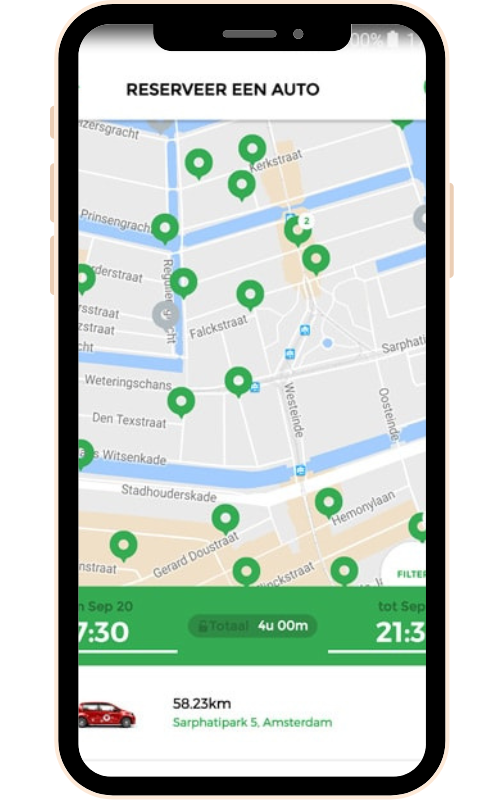
The Greenwheels physical presence on Dutch streets combines with virtual life on the mobile app to drive an increase of more than 100% in customers since it launched its app revamp in 2015. Whenever customers want to rent a vehicle, they see a cluster of Google Maps pins where Greenwheels cars are stationed. The customer simply picks the most convenient one for that trip, benefitting from other visible factors such as subway stations that help them plan their journey.
Customer base doubled in two years
According to Lisa de Vreede, Greenwheels Product Manager B2C, Google Maps Platform APIs are integral to every part of the Greenwheels customer journey, from choosing a car, to obtaining step-by-step directions to the vehicle and navigating to the final destination. The holistic picture enabled by Google Maps, she says, has contributed to significant performance gains.
Greenwheels, for example, experienced a 60% surge in app bookings after launching the app in 2016. Today 78% of Greenwheels app users use integrated Google Maps to book and find their car (the rest book favorite cars they have used multiple times.) Meanwhile, the app’s convenience has resulted in more customers booking online rather than over the phone, which can be time-consuming. In 2015, phone bookings made up the vast majority of orders, and required time and effort to fulfill. Today, more than 90% of orders come through the enhanced smartphone app, which means significant cost and labor savings for Greenwheels and an improved experience for its customers.
Perhaps the most important result of all is that the Greenwheels app supported by Google Maps Platform drives scalable business growth in step with demand, enabling it to grow rapidly.
“Without our app and Google Maps Platform, we could never have doubled our customer base in just two years. Our call center would have been overwhelmed,” says Lisa. “With Google Maps Platform, customers get a clear visual display of everything they need to know, they tap ‘book now’, and it’s done.”
Greenwheels is now using more Google solutions to drive its green growth journey. Google Firebase enables Greenwheels projects in every team, from marketing to product development and business strategy. “We’re a big fan of Google Firebase as an app analytics tool,” says Allard. “It gives us a huge range of solutions, powering the data analytics, providing intel for product, marketing, and enabling us to strategize the mobile customer experience.”
Strategic partnerships to build a greener future
Greenwheels has been working with Google Maps Premier Partner Localyse since adopting Google Maps Platform. The synergies between Localyse, Google Maps Platform, and Greenwheels, says Allard, enable the car sharing platform to discover unexpected ways to deploy Google Maps Platform APIs and keep abreast of product updates. In turn, the ongoing conversation inspires Greenwheels with ideas to evolve its own solution.
“It’s all about being open to new ways to think creatively about the APIs that Google Maps Platform is building. And that becomes the basis of ideas that transform our product offering,” says Allard.
One example of the productive synergies? Localyse advised Greenwheels to deploy Google My Business to pinpoint Greenwheels cars on Google Maps. “Google My Business is a solution normally used to locate a shop or an eatery on Google Maps, and using it to ‘mass publish’ the location of our cars was a new insight from Localyse that really made a difference, because it adds one more way for our customers to easily find our cars by glancing at Google Maps,” says Allard.
Today Greenwheels is accelerating its journey in green mobility. One key project is peer-to-peer solutions where individuals can offer their own car under the Greenwheels brand. It’s also working with property developers to create multimodal transportation hubs, enabling networks of cars, bicycles, and scooters to optimize journeys.

Lisa de Vreede
“We have strategy meetings with Localyse and Google Maps Platform where we discuss the problems we’re seeing, or opportunities we’re exploring, and then discuss what the possibilities are. It’s a meeting of the minds to invent new mobility solutions.”
Let's discuss your project
Looking for a way to make better decisions about your business’s location-based strategies? Look no further than Localyse!
Phone
