Google Premier Partner specialized in Location-Based Services.

Social Deal – Attract more local customers with Google Maps

Social Deal is a Dutch success where consumers can buy local experience and market leader in the BeNeLux with a 50 million turnover yearly and looking for European growth. Google Maps technology supports us to easily expand without the need of changing the map technology. Joining the platform, partners see a growth revenue, optimise the occupancy rate and attract more new local customers.

logo social deal

The Challenge

Social Deal is a platform on which the most interesting deals in the region are available. To display these deals, we needed a user-friendly environment. It’s key that the ordering process goes very smoothly and only takes a few clicks. Monthly over 1 million experiences are sold. A map to visualise the deals was preferred, a list view would be too cluttered.

The Solution

Google Maps proved to be a great success! We were directly capable to visualise all of our deals in an organised way without sacrificing user friendliness. In fact, Google Maps was our only option because consumers already know this map. Now we visualise all of our deals on the map and the user knows directly where they are. Another big advantage is that we are able to expand in the EU easily.

Scherm­afbeelding 2023 05 25 om 11.33.35
Rens van den Berg

Rens van den Berg

CEO Social Deal

“Localyse helped us by providing volume discounts and with valuable advice about the APIs. They keep us posted on the newest developments of Google Maps Platform. As they are a local partner it’s convenient that we can conversate in our own language.”

The Results

Social Deal is growing enormously, every two years we double our customer base and offerings. The integration with Google Maps Platform supports this growth strategy. By adding the “nearby” functionality customer satisfaction has grown 10% and bounce ratio has dropped 20%. Using another mapprovider wasn’t an option since it would detract from our website.

Let's discuss your project

Looking for a way to make better decisions about your business’s location-based strategies? Look no further than Localyse!

Email

Phone

🇳🇱 +31 (0)172 25 55 00 

Prato – Ideal job dispatching based on travel time & distance

Prato is a Belgian company that offers innovative HR software and services. Clients include interim agencies, service cheque companies and enterprises. Prato helps with automation of payroll and personnel administration as well as well-founded social-legal advice. The company is part of geneHRations, a network of HR-tech entrepreneurs that implement innovative solutions and turn them into profitable business.

Prato19 RGB LOGO

Some background

Among other HR tech solutions, Prato offers software for service voucher companies to automate the assignment of cleaning staff to households.

Service voucher companies employ cleaners and generate revenue via a voucher system set up by the Belgian government: They can redeem one voucher for each cleaning hour, regardless of the circumstances. In order to make a profit, these companies need to optimize the working hours of their employees for cleaning time to avoid long commutes and planning efforts.

To help these companies with their scheduling, Prato’s software calculated travel times and distances for all employees. However, when their previous API provider’s prices suddenly increased significantly, their entire product was at stake. For this reason, Prato’s Technology Lead Tim Pijpops and Product Owner Daan Gielen asked Localyse for a new solution: Targomo came into play.

Sustaining a profitable product

Challenge: Sustaining a profitable product

Prato’s solution for service voucher companies has been on the market for years, but it unexpectedly came into jeopardy: “The cost of our previous API provider suddenly skyrocketed, making our product virtually unsellable,” Tim Pijpops explains. He turned to Localyse, which had previously supported his API implementation, in search of an alternative.

Solution: Quick & smooth transition to Targomo’s API

Localyse proposed Targomo’s Travel Time and Routing APIs as a cost-effective and powerful alternative. “Localyse’s engineers came to our office and provided hands-on support in implementing the new technology, so Prato could continue to offer its product for a reasonable cost increase” says Daan Gielen. Travel time calculation is at the heart of Prato’s product, as it is central to optimizing employee commute times. After extensive testing of the previous and new calculations, all of Prato’s customers smoothly migrated to Targomo’s API within a few months.

Ontwerp zonder titel 12

Employees use different modes of transport

Challenge: Employees use different modes of transport

Service voucher companies have to take into account that their employees in general prefer different modes of transportation to reach the households. They also have to be able to consider daydependent variations in the means of transport to still calculate correct data for the billing process.

An employee travelling by public transit will necessarily lead to other travel time calculations than the same employee travelling by car, and travelling by car during rush hour will take longer than outside.

Solution: Travel times and distances are based on means of transportation

Once the relevant transport modes were defined, Localyse implemented Targomo’s Travel Time API in a way that allows Prato’s software users to customize their calculations: Per employee, they can set a standard mode of transportation (i.e. “car”, “bike”, “e-bike”, “transit”) and adjust it for specific days.

Targomo’s API then automatically takes into account travel speed, possible routes, and in the case of transit, the public transportation schedules in order to produce accurate results. The service voucher company also has the option to visualize the route through Targomo’s Routing API with a single click.

Zonder titel 1200 x 600 px 2

Results

Profitable, cost-effective software product

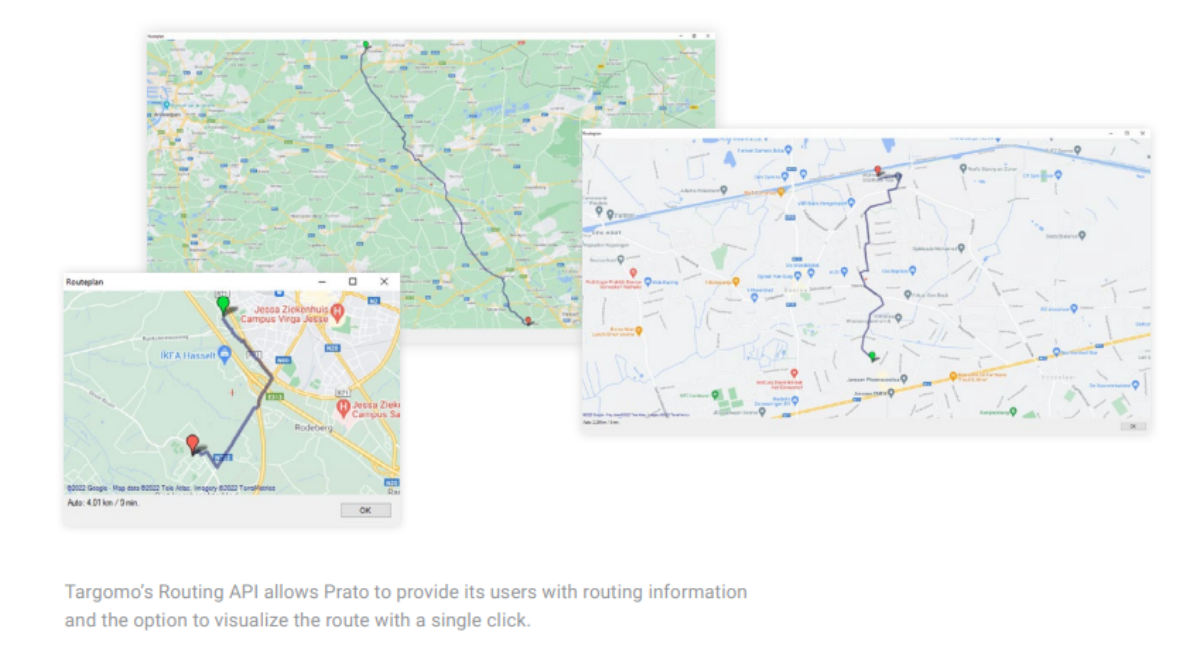
Due to Targomo’s competitive pricing, Prato can continue to offer an innovative and highly efficient software product to its customers: “Travel time calculations are at the core of our solution. Switching to Targomo’s API really saved our product,” Tim Pijpops acknowledges.

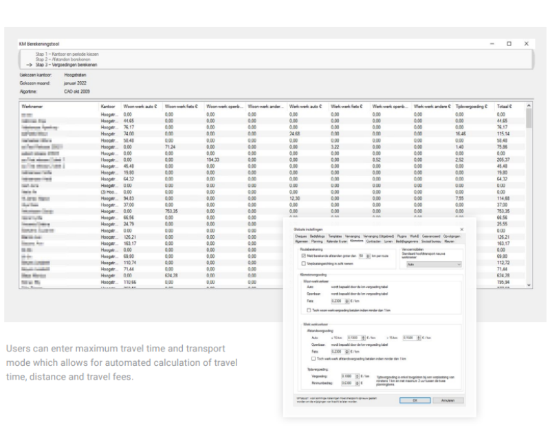
Scheduling within seconds

To Prato’s customers, there is practically no alternative to fast and automated travel time calculations. Previously, everything had to be done manually, leading to an enormous overhead. “Our biggest client runs up to a million travel time calculations each month and gets results instantly,” Daan Gielen explains. That’s around 35.000 calculations per working day.

High accuracy

In the voucher service business, travel time and distance are relevant for payroll, so accuracy is key. Although the users of Prato’s software have the chance to overwrite some automatically calculated values, this is nearly never done – a clear indicator for the reliability of the results. Gielen adds: “We as well as our customers benefit from the precision of Targomo’s calculations, so we can trust in the data”.

Let's discuss your project

Looking for a way to make better decisions about your business’s location-based strategies? Look no further than Localyse!

Email

Phone

🇳🇱 +31 (0)172 25 55 00 

MachineMax – Drilling into data tracked from mining and construction equipment

The metals, mining, and construction industries rely on heavy off-road equipment for drilling, digging, and transporting goods and people in often remote and difficult to access parts of the world. If this equipment is poorly maintained, is used inefficiently, or even not used at all, it is not being used cost-effectively, which negatively impacts productivity. It could also result in the burning of excess fuel and unnecessary carbon emissions, plus it could lead to expensive repairs that could have been less severe if they were picked up earlier.

Locating and tracking off-road equipment for optimal use

A subsidiary of Dutch energy company Royal Dutch Shell, MachineMax, produces equipment management platforms that connect to sensors positioned on various parts of off-road equipment to monitor its location, usage, and condition. “We connect all the heavy equipment assets that tend to be used in mining and construction to build complete remote visibility of what’s happening on-site through a single user interface,” explains Jennifer Thomson, Chief Growth Officer at MachineMax. “Operators can plug into the real-time data that we collect and use it in a smart way to understand what’s happening on-site and then take steps to improve the performance of their equipment and drive sustainability, efficiency, and profitability.”

Drilling into data tracked from mining and construction equipment 1

Lina Alagrami

Lead Engineer, MachineMax

“We chose Google Cloud and Google Maps Platform because they can scale with us and cover the globe, and also because we knew what we wanted to build and the tools that we needed to do it and Google had them all, so we could use them from the start.”

Mapping out an integrated future

As geopositioning is such an integral part of MachineMax’s offering, it also needed to launch with a suite of tracking tools that would integrate with Google Cloud, and Google Maps Platform was the obvious choice.

“We chose Google Maps Platform because it made sense to work with another Google product, its functionality seemed to outperform its competitors, and from a usability perspective, people are familiar with its tooling, but most importantly it integrates with a large number of APIs for geometry, drawing, places, and visualization,” explains Riccardo Rizzo, Lead React and iOS Engineer at MachineMax.

To provide a true representation of what is going on in a specific location, MachineMax uses a variety of APIs to show its customers the coordinates of where their off-road equipment is located, its condition, where it is in relation to other equipment in the field using geofences and to provide a visual picture with satellite imagery.

“With tools such as Heatmap Layer we can show, for example, excessive idling. This is where a vehicle or multiple vehicles are sitting with their engines on, burning fuel, emitting CO2, and being unproductive. And, we might even be able to show that this is happening because a load of dump trucks is backed up waiting to be loaded,” says Kate Stephen, Head of Product and Design at MachineMax.

Drilling into data tracked from mining and construction equipment 2

Getting data from remote areas

Although MachineMax implemented its Google Cloud and Google Maps solutions in-house, it wanted to further improve the accuracy of its GPS. Google suggested it call on the support of Google Cloud Premier Partner, Localyse to help it with this specific issue.

“We needed to try and increase the accuracy of our GPS, and there are several factors that can influence this, but the biggest factor is the number of satellites in view,” says Rizzo. “Localyse helped us to filter out all the GPS points that use a low number of satellites and also to use machine learning to reproduce a point from a previous point to help create a more accurate picture.”

Jennifer Thomson

Chief Growth Officer - MachineMax

“We know that with the support of Google Cloud and Google Maps, we can drill even deeper into the parameters of the data that we collect to help our customers become more profitable, more efficient, and more sustainable.”

Drilling into data tracked from mining and construction equipment 3

Let's discuss your project

Looking for a way to make better decisions about your business’s location-based strategies? Look no further than Localyse!

Email

Phone

🇳🇱 +31 (0)172 25 55 00 

Localyse as Micpoint’s map advisor

Micpoint is a company which offers (cloud) solutions for: fleet management, vehicle security and animal registration. Besides that, the company has a particular origin story, it came forth from a bet, fast forward 30 years, it’s a thriving family business. Their portfolio includes respectable clients such as Koninklijke BAM, Alliander, Vodafone Ziggo,…

logo micpoint block white 1

Optimizing data leak prevention with location intelligence

Micpoint automates certain processes to provide a safe and trusted environment for their customers. The major benefit that comes with automating these processes, is data leak prevention. However, Micpoint was looking for a way to optimize their automation processes.

Eagerly, Localyse wanted to help, we introduced several map providers out of which Anymap was the best fit for Micpoint. This tool allows Micpoint’s users to obtain address data in milliseconds through geocoding which means, better data leak prevention. Furthermore, Anymap runs on Google Cloud’s platform which means the retrieved data is always reliable. In addition, Micpoint is now able to gather address data twice as quickly as the previous map provider.

Localyse’s expert guidance

As stated above we brought forth multiple map providers for Micpoint to choose out of. However, Anymap was the perfect fit for Micpoint because it met Micpoint’s needs perfectly.

Frank Leemkuil

Micpoint BV

Localyse gave us space to test multiple map providers. Thanks to  the hybrid Anymap and expert guidance from Localyse, we found a map solution that seamlessly meets our needs in terms of functionality, performance and price.

Let's discuss your project

Looking for a way to make better decisions about your business’s location-based strategies? Look no further than Localyse!

Email

Phone

🇳🇱 +31 (0)172 25 55 00 

Localyse optimizes expense management experience for Mobilexpense

Mobilexpense is a European tech group committed to simplifying expense management for multinationals and SME’s. Their software offers an all in one expense management solution. Furthermore, Mobilexpense has an impressive portfolio which consists of companies such as ABInBev and Promximus.

juist mob kopieren

Improving Mobilexpense’s software

Mobilexpense’s software is integrated in a wide range of travel providers. This allows for: 

Thanks to the use of location intelligence we were able to optimize Mobilexpense’s software. Now, the users’ experience when booking and expensing travel is even better. Localyse assisted Mobilexpense in integrating Google Maps’ API’s in its product portfolio, improving the legal mileage calculation process. Now, a more accurate overview can be consulted to view the legal mileage that needs to be reimbursed to employees.

Together with receipt data extraction, daily allowance calculations and direct links with credit card transactions, location intelligence integrations provide Mobilexpense with a reliable and easy-to-use expense management tool.

Location intelligence Integration

Together with receipt data extraction, daily allowance calculations and direct links with credit card transactions, location intelligence integrations provide Mobilexpense with a reliable and easy-to-use expense management tool.

Let's discuss your project

Looking for a way to make better decisions about your business’s location-based strategies? Look no further than Localyse!

Email

Phone

🇳🇱 +31 (0)172 25 55 00 

LISER: Data analysis made easy

The well established public research organization LISER delivers valuable data which is used for numerous studies. This comprehensive data is gathered through various sources to obtain objective results. LISERS’s main objective is to support public policy on a national level as well as on a European level.

LISER logo

The value of demographic address data

LISER gathered lots of market and demographic address data which was then used for their research and data analytics. Their main goal was to visualize this data and plot it on a map to generate insights. This map could then be used as a guideline to make informed reports and analysis regarding the European labor markets.

Localyse’s role

Localyse, chose for Google API’s to structure, clean and enrich LISER’s bulks of datastrings. We were able to execute this with a massive success rate therefore, their data could be used in specific research operations.

Success

This method is also applicable on other heaps of data, making it possible to generate insights and take well substantiated business decisions. Think classic CRM, e-commerce or many other sorts of data.

Let's discuss your project

Looking for a way to make better decisions about your business’s location-based strategies? Look no further than Localyse!

Email

Phone

🇳🇱 +31 (0)172 25 55 00 

Localyse creates magic widget for Breda

Breda is a lively (and lovely) city and municipality in the southern part of the Netherlands. It’s the perfect getaway if you want to relax and get to know Dutch culture a bit more. There are plenty of interesting museums, renowned art galleries, amazing restaurants etc.

Breda logo

Google Maps powered widget

Breda was looking for a tool that allows you to view specific points of interest in the city. Eagerly, Localyse wanted to help. We created an easy to use widget which allows users to filter through certain points of interest such as: public bathrooms, parkings, water taps and many more. Important to know is that this widget also makes it incredibly easy to see which interest points are accessible to people with a disability. 

The coming months there will be many events taking place in Breda, including a stage of the cycling tournament La Vuelta! That’s why we embedded the widget into several event- and point of interest-websites like the Stedelijk MuseumWelkom in Breda and more to facilitate visitors of these events in an inclusive and accessible way.

Not solely for Breda

Localyse created this widget for the city of Breda, however, this tool can be integrated on other websites as well.

Let's discuss your project

Looking for a way to make better decisions about your business’s location-based strategies? Look no further than Localyse!

Email

Phone

🇳🇱 +31 (0)172 25 55 00 

Localyse helps Dopper to make water taps visible in Google Maps

Dopper, a renowned company for its ingenious drinking bottles, is on a mission. A mission to empower people to choose reusable water bottles over single-use ones. In this way, less plastic gets scattered around our globe.

Scherm­afbeelding 2023 03 07 om 11.54.13

Updating reality

Research has shown that although the Netherlands has 1,872 water taps in public spaces, many people don’t know where to find them. That’s why Dopper called in Localyse for help to put those 1,872 water taps on the digital map. From now on you can search for ‘water tap’ in Google Maps and find the nearest water tap near you.

Virginia Yanquilevich, CEO of Dopper: “By making it clear where you can refill your bottle, we made it easier for people to re-use it. We think it should be ‘the new normal’ that every person carries a refillable bottle with them. This is one of the most simple ways to do your bit for achieving cleaner oceans.”

Location data at its finest

Jeffrey Benning, Country Manager Localyse, was involved in the project from the start: ‘At Localyse, we are always looking for possibilities on how location data can support an organisation in its mission. We came into contact with Dopper as they wondered why water taps were not easy to find on Google Maps and whether we could help them with this. It’s fantastic that this project has been successfully achieved and that so many water taps are now easy to find by everybody! At Localyse we are delighted and proud to contribute to Dopper’s mission and to use our specialism for such a social cause.’

Success during the first week

Screenshot 2022 06 07 20.09.13

Let's discuss your project

Looking for a way to make better decisions about your business’s location-based strategies? Look no further than Localyse!

Email

Phone

🇳🇱 +31 (0)172 25 55 00