Google Premier Partner specialized in Location-Based Services.
As location-based services specialised partner, Localyse offers the billing- and account management of the Google Earth Engine license and Google Cloud Platform budget to Rijkswaterstaat, to facilitate the ‘Vegetation Monitor’-application.
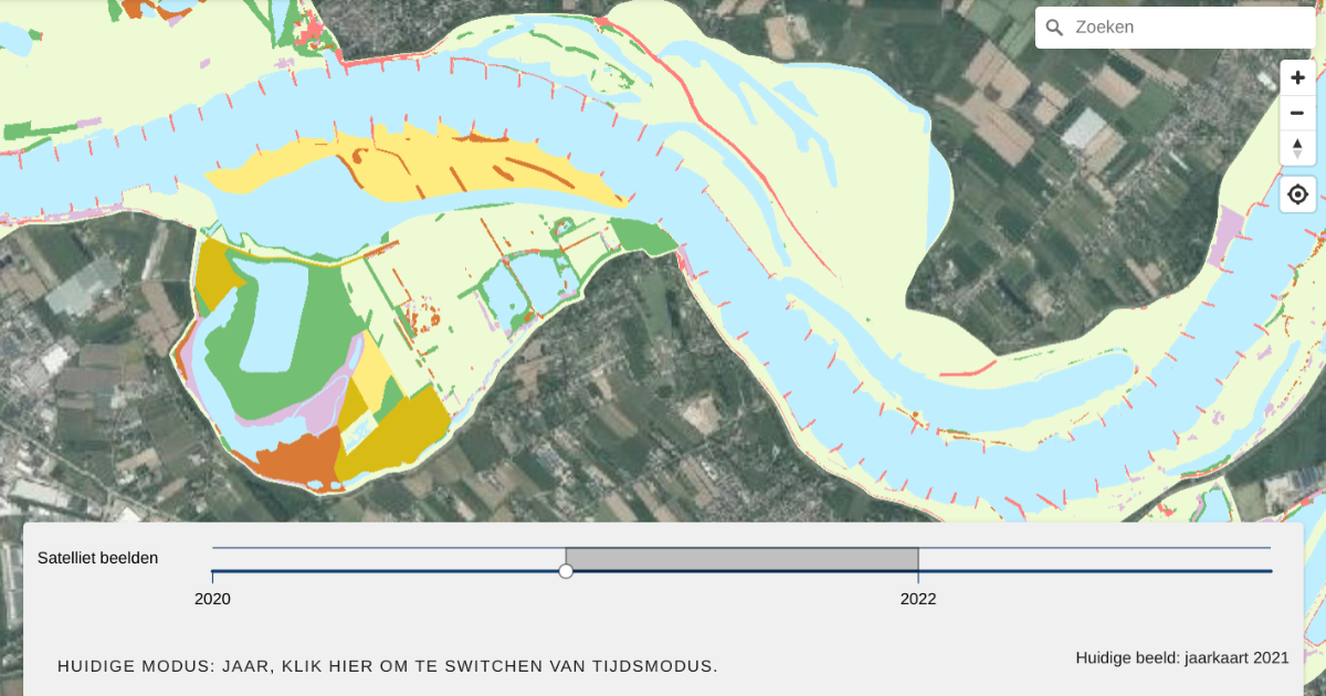
Rijkswaterstaat must annually assess the development of vegetation growing along the Meuse and the Rhine rivers in the Netherlands. This is done to prevent obstruction of the river flow in the Delta. The river flow zone needs to be kept to its full capacity to deal with heavy rain fall and spring melting water, that otherwise could overflow the dikes and inhabited land areas.
Deltares, an independent institute for applied research in the field of water and the subsurface, has developed a web viewer tool based on Google Earth Engine, that visualizes and compares vegetation development levels from satelite imagery, and compares these to a central map legger from Rijkswaterstaat, allowing maintenance organisations to pinpoint where to manage vegetation.
Using the vast amount of Google Earth Engine satellite imagery in the vegetation monitor, maintenance organisations and inspecting bodies can now monitor larger areas with less capacity, keep an eye out on specific areas without physically being there, and have a near real-time monitoring of how the vegetation develops.
Would you like to be sure that your location is easy to find and access? Feel free to contact us via the contact form below. We are happy to think along with you and provide insight into potential improvements to your visibility and accessibility.
Your privacy settings
Manage Consent Preferences
Necessary
Analytics
Embedded Videos
Marketing
Facebook Advanced Matching
Facebook CAPI