Google Premier Partner specialized in Location-Based Services.

LISER: Data analysis made easy

The well established public research organization LISER delivers valuable data which is used for numerous studies. This comprehensive data is gathered through various sources to obtain objective results. LISERS’s main objective is to support public policy on a national level as well as on a European level.

LISER logo

The value of demographic address data

LISER gathered lots of market and demographic address data which was then used for their research and data analytics. Their main goal was to visualize this data and plot it on a map to generate insights. This map could then be used as a guideline to make informed reports and analysis regarding the European labor markets.

Localyse’s role

Localyse, chose for Google API’s to structure, clean and enrich LISER’s bulks of datastrings. We were able to execute this with a massive success rate therefore, their data could be used in specific research operations.

Success

This method is also applicable on other heaps of data, making it possible to generate insights and take well substantiated business decisions. Think classic CRM, e-commerce or many other sorts of data.

Let's discuss your project

Looking for a way to make better decisions about your business’s location-based strategies? Look no further than Localyse!

Email

Phone

🇳🇱 +31 (0)172 25 55 00 

Localyse creates magic widget for Breda

Breda is a lively (and lovely) city and municipality in the southern part of the Netherlands. It’s the perfect getaway if you want to relax and get to know Dutch culture a bit more. There are plenty of interesting museums, renowned art galleries, amazing restaurants etc.

Breda logo

Google Maps powered widget

Breda was looking for a tool that allows you to view specific points of interest in the city. Eagerly, Localyse wanted to help. We created an easy to use widget which allows users to filter through certain points of interest such as: public bathrooms, parkings, water taps and many more. Important to know is that this widget also makes it incredibly easy to see which interest points are accessible to people with a disability. 

The coming months there will be many events taking place in Breda, including a stage of the cycling tournament La Vuelta! That’s why we embedded the widget into several event- and point of interest-websites like the Stedelijk MuseumWelkom in Breda and more to facilitate visitors of these events in an inclusive and accessible way.

Not solely for Breda

Localyse created this widget for the city of Breda, however, this tool can be integrated on other websites as well.

Let's discuss your project

Looking for a way to make better decisions about your business’s location-based strategies? Look no further than Localyse!

Email

Phone

🇳🇱 +31 (0)172 25 55 00 

Localyse helps Dopper to make water taps visible in Google Maps

Dopper, a renowned company for its ingenious drinking bottles, is on a mission. A mission to empower people to choose reusable water bottles over single-use ones. In this way, less plastic gets scattered around our globe.

Scherm­afbeelding 2023 03 07 om 11.54.13

Updating reality

Research has shown that although the Netherlands has 1,872 water taps in public spaces, many people don’t know where to find them. That’s why Dopper called in Localyse for help to put those 1,872 water taps on the digital map. From now on you can search for ‘water tap’ in Google Maps and find the nearest water tap near you.

Virginia Yanquilevich, CEO of Dopper: “By making it clear where you can refill your bottle, we made it easier for people to re-use it. We think it should be ‘the new normal’ that every person carries a refillable bottle with them. This is one of the most simple ways to do your bit for achieving cleaner oceans.”

Location data at its finest

Jeffrey Benning, Country Manager Localyse, was involved in the project from the start: ‘At Localyse, we are always looking for possibilities on how location data can support an organisation in its mission. We came into contact with Dopper as they wondered why water taps were not easy to find on Google Maps and whether we could help them with this. It’s fantastic that this project has been successfully achieved and that so many water taps are now easy to find by everybody! At Localyse we are delighted and proud to contribute to Dopper’s mission and to use our specialism for such a social cause.’

Success during the first week

Screenshot 2022 06 07 20.09.13

Let's discuss your project

Looking for a way to make better decisions about your business’s location-based strategies? Look no further than Localyse!

Email

Phone

🇳🇱 +31 (0)172 25 55 00 

Greenwheels – Creating more livable towns with a car sharing app

The Netherlands may be known for its love affair with bicycles, but many people still rely on cars to get around, which means that the country is facing similar congestion and air pollution issues to the rest of the world. That’s what inspired Greenwheels to launch a car sharing service with a mission to “make cities more livable” by putting a fuel-efficient car around the corner from every Dutch home.

greenwheels logo

With Greenwheels, cars are parked a convenient walking distance from anybody in a town or city. Registered users open their vehicle with their smartphone or a public transport card and collect the key inside the glove compartment by entering a pin. They only pay for the miles they drive.

Four years ago, Greenwheels rebooted its dream of bringing back Dutch open spaces, with a new app powered by Google Maps Platform. Since then, an environmental mission that started 25 years ago has been picking up speed. A study by Dutch mobility consultancy Goudappel Coffeng shows that every new addition to the Greenwheels fleet takes 11 cars off the street. After joining Greenwheels, people drive an average of roughly 1,242 miles less per year, saving 16 tons of annual CO2 emissions for all customers.

“We’ve been in this business for a quarter of a century, and we see ourselves as pioneers of the global car sharing boom,” says Allard Hansma, Manager Marketing & Sales at Greenwheels. “Our app revamp, with a whole new customer experience powered by Google Maps Platform, marked the moment we saw a huge jump in our business and environmental performance.”

Zonder titel 800 x 630 px 9

Making car sharing vehicles easier to find

A huge amount of thought goes into seemingly random placement of car sharing vehicles. We avoid, for example, positioning vehicles near bridges in Holland. Why? They’re always opening and closing to allow canal traffic, meaning customers can get stuck leaving or returning. Big trees are also to be avoided, to prevent the vehicle from being soiled by birds. In addition, Greenwheels seeks high-visibility locations. “Cars are our billboards, so these areas are prime advertising real estate,” Allard explains.

Allard calls such insights part of “a cocktail of experience” gained from more than 25 years in business. And Google Maps Platform, in particular the Maps Javascript API and the Maps Street View Service, are powerful enablers in leveraging this wealth of knowledge. The Maps Javascript API provides the big picture of vehicle placement, by dynamically layering landmarks such as thoroughfares and important buildings, says Allard. The Maps Street View Service, meanwhile, acts as the platform’s eyes on the street to spot trees and bridges and other real-life factors that determine its choices.

“We have an entire department devoted to finding ideal locations for stationing cars,” says Allard. “And we rely on Google Maps Platform solutions such as the Maps Javascript API and the Maps Street View Service to deliver a precise picture of urban layouts to optimize placement strategy.”

The Greenwheels physical presence on Dutch streets combines with virtual life on the mobile app to drive an increase of more than 100% in customers since it launched its app revamp in 2015. Whenever customers want to rent a vehicle, they see a cluster of Google Maps pins where Greenwheels cars are stationed. The customer simply picks the most convenient one for that trip, benefitting from other visible factors such as subway stations that help them plan their journey.

Customer base doubled in two years

According to Lisa de Vreede, Greenwheels Product Manager B2C, Google Maps Platform APIs are integral to every part of the Greenwheels customer journey, from choosing a car, to obtaining step-by-step directions to the vehicle and navigating to the final destination. The holistic picture enabled by Google Maps, she says, has contributed to significant performance gains.

Greenwheels, for example, experienced a 60% surge in app bookings after launching the app in 2016. Today 78% of Greenwheels app users use integrated Google Maps to book and find their car (the rest book favorite cars they have used multiple times.) Meanwhile, the app’s convenience has resulted in more customers booking online rather than over the phone, which can be time-consuming. In 2015, phone bookings made up the vast majority of orders, and required time and effort to fulfill. Today, more than 90% of orders come through the enhanced smartphone app, which means significant cost and labor savings for Greenwheels and an improved experience for its customers.

Perhaps the most important result of all is that the Greenwheels app supported by Google Maps Platform drives scalable business growth in step with demand, enabling it to grow rapidly.

“Without our app and Google Maps Platform, we could never have doubled our customer base in just two years. Our call center would have been overwhelmed,” says Lisa. “With Google Maps Platform, customers get a clear visual display of everything they need to know, they tap ‘book now’, and it’s done.”

Greenwheels is now using more Google solutions to drive its green growth journey. Google Firebase enables Greenwheels projects in every team, from marketing to product development and business strategy. “We’re a big fan of Google Firebase as an app analytics tool,” says Allard. “It gives us a huge range of solutions, powering the data analytics, providing intel for product, marketing, and enabling us to strategize the mobile customer experience.”

Zonder titel 800 x 630 px 10

Strategic partnerships to build a greener future

Greenwheels has been working with Google Maps Premier Partner Localyse since adopting Google Maps Platform. The synergies between Localyse, Google Maps Platform, and Greenwheels, says Allard, enable the car sharing platform to discover unexpected ways to deploy Google Maps Platform APIs and keep abreast of product updates. In turn, the ongoing conversation inspires Greenwheels with ideas to evolve its own solution.

“It’s all about being open to new ways to think creatively about the APIs that Google Maps Platform is building. And that becomes the basis of ideas that transform our product offering,” says Allard.

One example of the productive synergies? Localyse advised Greenwheels to deploy Google My Business to pinpoint Greenwheels cars on Google Maps. “Google My Business is a solution normally used to locate a shop or an eatery on Google Maps, and using it to ‘mass publish’ the location of our cars was a new insight from Localyse that really made a difference, because it adds one more way for our customers to easily find our cars by glancing at Google Maps,” says Allard.

Today Greenwheels is accelerating its journey in green mobility. One key project is peer-to-peer solutions where individuals can offer their own car under the Greenwheels brand. It’s also working with property developers to create multimodal transportation hubs, enabling networks of cars, bicycles, and scooters to optimize journeys.

Lisa de Vreede

Lisa de Vreede

Product Manager Greenwheels

“We have strategy meetings with Localyse and Google Maps Platform where we discuss the problems we’re seeing, or opportunities we’re exploring, and then discuss what the possibilities are. It’s a meeting of the minds to invent new mobility solutions.”

Let's discuss your project

Looking for a way to make better decisions about your business’s location-based strategies? Look no further than Localyse!

Email

Phone

🇳🇱 +31 (0)172 25 55 00 

Solutions 4 Delivery – Disrupting Quick Service Restaurant delivery via innovative SaaS products

The point-of-sale (POS) system is about much more than the moment a customer pays for a pizza. Today, it’s the critical hub that brings together logistics, inventory, customer management, and more, enabling these parts to move like clockwork. The payoff is a hot pizza at the doorstep at exactly the moment it’s expected (and a happy customer).

Logo small

In 2016, the founder of a Dutch pizza chain was seeking ways to upgrade operations to allow his growing business to expand even faster. The weak link, he determined, was an outdated POS system that couldn’t keep up with potential demand.

This insight led him to Solutions 4 Delivery, a startup with a mission to build smart, innovative technologies that enable franchise food delivery companies to scale efficiently. Looking around the industry, they found many successful chains that struggled to scale due to dated, legacy systems. They set out to create an end-to-end POS system that seamlessly integrates the processes triggered by a transaction.

To make this possible, Solutions 4 Delivery needed a world-class mapping solution for optimized delivery. By choosing Google Maps Platform, the startup found much more than the quickest way to get from point A to B. Google Maps traffic, distance, and routing calculations enabled pinpoint precision in other key aspects of the POS workflow, from deciding which meals to cook first, to how to manage stock, choose the right vehicle, and even onboard new staff.

“There’s a complex web of factors that goes into a meal being delivered within 30 minutes,” says Maxim Vaz Dias, Business Development Manager, Solutions 4 Delivery. “Google Maps Platform transforms our POS capabilities across the board. The Places API, Directions API, and Maps Javascript API let us know when to fire up ovens, whether to send out a scooter or car, and how much inventory is needed in delivery areas. Plus the intuitive user interface embedded on our system makes onboarding workers so easy, as they’re already familiar with the look and feel of Google Maps.”

Zonder titel 800 x 630 px 7

Building tailor-made POS solutions for unique location needs

For Solutions 4 Delivery, one of the challenges in designing an optimal POS system is that one size does not always fit all. In a market like Romania, an emerging European country, traffic and road conditions are known to be erratic. Food delivery times depend on this unpredictable nature of daily life. By contrast, in the Netherlands, ultra-modern infrastructure and compact urban layouts mean food deliveries rarely take more than 10 minutes.

Solutions 4 Delivery created a software-as-a-service (SaaS) POS system for food delivery franchises for a range of environments. That means partnering with each client to craft an individualized POS strategy. The startup’s unique value lies in combining the ease of plug-and-play with the versatility of custom-made solutions.

To make this vision work, Solutions 4 Delivery needed a robust array of powerful mapping tools to underpin the flexibility of its product. Google Maps Platform met this need with a range of location-based APIs. Just as importantly, Maxim says, the Google team together with partner Localyse shared Solutions 4 Delivery’s ethos of partnering to grow together. It enabled creative discussion on how to get the most out of the range of Google Maps Platform APIs.

“We strive to be the partner who month-by-month shows our clients new POS enhancements that will grow their business,” says Maxim. “We have a different approach from just being the vendor thinking about the next sale. So it’s important for us that Google Maps Platform and partner Localyse take the same approach, working as a team to build new solutions.”

On-time delivery with the Directions API and Maps Javascript API

Solutions 4 Delivery’s approach has yielded significant results for both its business and its food delivery clients across Europe.

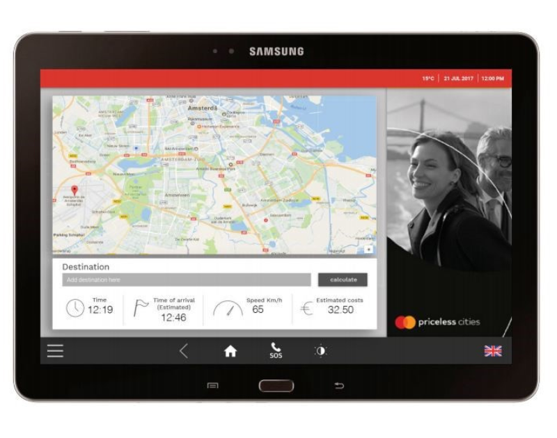
The combination of the Maps JavaScript API’s real-time traffic and the Directions API’s route optimization enables a more efficient workflow that yields an average 23.5% reduction in the number of delivery runs using Solutions 4 Delivery’s POS system.

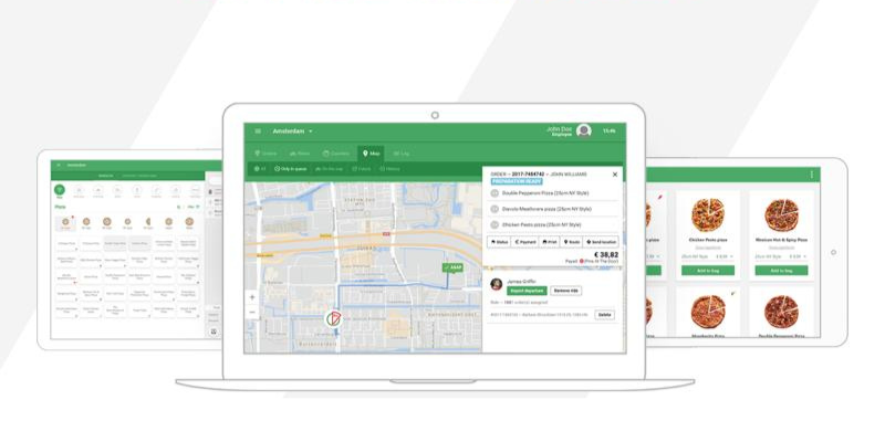
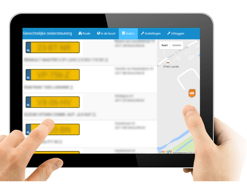
Because the end-to-end process is connected in today’s POS system, accurate location intelligence enables Solutions 4 Delivery to optimize seemingly disparate operations. These activities include the order of cooking meals, bundling those meals into delivery runs, and selecting the right vehicle for each run (with the choice between fast cars or nimble bikes determined by traffic congestion and street layout).

“The result of Google Maps Platform integration is simply faster delivery and lower overhead,” says Maxim. “Cutting delivery runs by nearly a quarter has yielded cost savings of 10% by requiring fewer drivers and vehicles.”

Meanwhile, ETA accuracy is a key differentiator between success and failure in food delivery. For Solutions 4 Delivery, the Distance Matrix API and Traffic Layer in Maps JavaScript API produces an average 3% improvement in ETA accuracy over all markets served. In less developed markets like Romania, the ETA boost is much higher, at an estimated 17%, as Maps Javascript API’s Traffic Layer brings clarity to unstable road conditions.”This brings a huge boost to customer satisfaction,” says Maxim. “In Romania, if we give an ETA that’s slightly longer than usual, and the ETA is spot on, the customer is still happy. What they hate is being told one thing and getting another. Google Maps Platform allows our clients to meet expectations every time.”

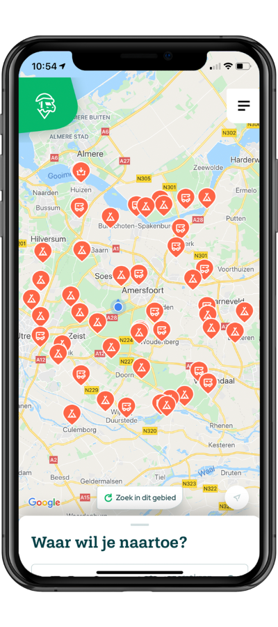
For Solutions 4 Delivery, one unexpected advantage of Google Maps Platform is decreasing the training time food chains require to onboard new staff. The POS systems built by Solutions 4 Delivery provides the intuitive Google Maps user interface (UI) that employees already use in their daily lives.

That means the tablets and mobile apps on which POS systems communicate have the familiar feel of Google Maps features many younger workers have used most of their lives. It yields an estimated 60% saving in training time, which also translates into cost savings.

“When we look at who is working in these stores, it’s mostly tech-minded young people, the new generation, and for them it’s pretty difficult to understand the older legacy-based POS systems,” says Maxim. “So we created a system that was way simpler to use with Google Maps UIs, which they already know from using Google Maps on their smartphones. For them, our POS system is as easy as navigating with Google Maps on their mobile device.”

Maxim Vaz Dias

Maxim Vaz Dias

Business Development Manager, Solutions 4 Delivery

“The result of Google Maps Platform integration is simply faster delivery and lower overhead. Cutting delivery runs by nearly a quarter has yielded cost savings of 10% by requiring fewer drivers and vehicles.”

Expanding into the US market and beyond with AI solutions

Solutions 4 Delivery plans to launch in the United States, hoping to accelerate the growth it has already seen, having expanded from four employees just three years ago, to 50 today. The team is looking at new Google Cloud features such as the Dispatcher API will further optimize delivery sequencing, enhancing client competitive advantage.

They key will be gaining as much insight as possible from these data resources, says Maxim, which is one reason why Solutions 4 Delivery is looking at Google Cloud AI and machine learning solutions for the next chapter in its growth journey.

“We foresee using Google Cloud AI solutions such as Google Cloud AutoML and Google Cloud AI Platform in all parts of our business, from chatbots and customer relations management on the frontend to managing inventory on the backend,” he says. “We see huge opportunities here that facilitate global expansion. We believe that POS system transformation for food delivery will only grow in importance. And Google Maps Platform and Google Cloud AI innovation will combine to allow us to invent more smart technologies to empower food delivery companies and help them scale.”

As Solutions 4 Delivery expands across Europe and into the US, it’s been able to look more broadly at delivery data to identify trends that will make its POS platform increasingly powerful. Data from Solutions 4 Delivery customers (mainly mid-sized players with a few hundred to thousands of stores) can be pooled, which allows them to start to compete with global food delivery giants.

Let's discuss your project

Looking for a way to make better decisions about your business’s location-based strategies? Look no further than Localyse!

Email

Phone

🇳🇱 +31 (0)172 25 55 00 

Activ84Health – Patients revitalized re-exploring the world through Google Street View

With the Memoride platform, developed by Activ84Health, patients revitalized can re-explore the world through cycling with Google Street View. Activ84Healh is a Belgian start-up, established in 2015, that develops technology to keep persons with a restriction physically and cognitively active in a fun, motivating and safe environment. Activ84Health’s first technology is the Memoride platform.

4f346e8c70c14a6b36317a9762963f19 b2ad94846f1815146a1e35902ef6e3f1

Challenge

The concept behind Activ84Health’s Memoride was developed by Jan Smolders, director of Nursing Home Witte Meren, who noticed that while exercising in their weekly physiotherapy sessions, nursing home inhabitants were simply looking at a wall while riding a stationary bike for 15-20 minutes. As this has no value in respect of “user experience” and does not stimulate users to increase their level of physical activity, Jan designed the concept for what would eventually become Memoride. A virtual environment where users would be able to explore the world outside of the nursing home, in search of memories of the past, stories to be told, and experiences to be relived.

Solution

The Memoride technology is a cloud-based software platform that allows users with a physical, logistic or cognitive restriction to combine physical activity with a valuable user experience, maximizing the functional capacities they have without being stigmatizing towards the restrictions they might suffer. As Activ84Health uses Google Street View images, they create a unique and personalised user experience by offering access to streets and locations, with high emotional value for the users.

As they typically spend most of their lives within the four walls of a
nursing home, hospital or rehabilitation centre, being able to virtually go outside again and relive past experiences or explore new environments provides a unique experience. Apart from the joy of being able to auto- nomously define how to exercise, where to go, and how to get there, Activ84Health also noticed that taking users back to the places of their past spontaneously provoked storytelling and reminiscence. This way, Memoride also has an effect on the cognitive activity of users. And even more, some of our clients have regular sessions in which 20-30 persons gather and go on a virtual city trip together. As such, they create a social experience by sharing memories and stories.

Zonder titel 800 x 630 px 3

Benefits

Implementing Google Maps in Activ84Health’s Memoride technology truly harnesses the unique proposition of Memoride. Without Google Maps, Activ84Health would not have been able to even start their company in the first place. On top they certainly would not have being able to roll out Memoride so quickly in different countries.

Let's discuss your project

Looking for a way to make better decisions about your business’s location-based strategies? Look no further than Localyse!

Email

Phone

🇳🇱 +31 (0)172 25 55 00 

GGN Mastering Credit – Improving on-the-road productivity of financial consultants

GGN Mastering Credit offers invoice-collection services for businesses and credit counseling help for consumers in need. GGN is market leader with 14 offices, including in Amsterdam, Rotterdam and The Hague. With a total of 1,000 employees, they are able to excel in the field of credit management and are thus able to deliver quality services to their customers.

Logo GGN fc zonder descriptor bijgesneden

Challenge

GGN Mastering Credit provides invoice-collection services for businesses and credit counseling services for consumers struggling with debt. Its 100 financial consultants make house visits to help consumers most easily pay outstanding invoices and help with debt issues. The company needed a mapping platform for a routing app to optimize driving routes its consultants take and provide instant access to financial data when they arrive. It chose Google Maps APIs as the ideal solution because it has the most comprehensive mapping information and easy-to-use interface.

Solution

Every morning, tablets used by GGN Mastering Credit consultants are pre-loaded with addresses of the consumers they will visit that day. The Google Maps Javascript API displays a map overlaid with routes to the consumers, so consultants can quickly get to their destinations. The consultants use Google Street View to know they have arrived at the right locations. When consultants meet with consumers, they have the financial information they need on their tablets. The web-based app has improved consultants’ productivity, helped resolve more invoices using information provided by the app, and allowed the consultants offer better advice to consumers. Consultants can now make at least 20 percent more visits per day and have reduced driving distances by at least 10 percent. Spending less time on the road allows them to spend more time with consumers, leading to invoices being resolved 10 percent faster. The extra time also lets consultants provide more in-depth help for consumers to solve their debt problems.

Zonder titel 800 x 630 px 2

Benefits

The amount of data about clients delivered by the software of GGN was connected to Google Maps. This connection made it possible to make graphical data visible were the clients live in relation to were the financial consultants are. So they can decide on their own where to make the next visit. Thanks to the digital information available in the tablet, the consultants don’t have to go back to the office to prepare for their next visits.

Arjen Houweling

“We built a tablet-based app with Google Maps APIs that helps our financial consultants visit more consumers every day, lets them spend more time with each and offers access to vital financial data.”

Let's discuss your project

Looking for a way to make better decisions about your business’s location-based strategies? Look no further than Localyse!

Email

Phone

🇳🇱 +31 (0)172 25 55 00 

Cabture – Making the time spent on traveling, worth it

Cabture is an ad/data-tech company, founded in 2014, in Amsterdam. It focuses its business’ activities around transportation & mobility, while being especially active in the taxi industry. Through its product, Cabture engages, entertains, and informs travellers. Cabture is growing significantly, being present in the Dutch market, and preparing for an expansion to Dubai.

ff80808161dfbeb80161e1cb67ee02e7 large

Challenge

One passenger felt that the time spent traveling was considered a huge waste of time. He created an idea of having a technology that would inform, entertain, and just make the traveling time much more usable! After much research and development, Screen&Wifi technology solution was created.

Solution

By using a Screen&Wifi (CabTab) digital technology in taxis, information can be forwarded, as well as collected, about the visitors. Highly digitalized and data-driven screens, revolutionary changed the passengers‘ experiences, whereas information is  customized and easily available. Applying cutting-edge technology in public transportation and taxis, turns them into gateways for data-driven communication. An interface – on which the screens and routers are running – is a data/content aggregator. It displays public- and touristic information, based on location proximity and time. Furthermore, it delivers information about the taxi driver, the city, shows a map, allows you to read the news, book tickets for museums, check-in for your next flight, watch a movie, or just browse the internet.

Zonder titel 800 x 630 px 1

Benefits

Data collected and analyzed by Cabture, allows taxi organizations to allocate their resources more efficiently. Increased service quality and additional features help taxi companies acquiring new customers, while differentiating themselves on the market. With the use of Cabture, over 76% of all the passengers, rated or provided feedback regarding the taxi driver. With this feedback, Cabture managed to increase the service and friendliness of the driver by 11%, whereas it used the feedback from passengers and remaining data to allocate drivers more efficiently. This way, companies manages to reduce waiting times and increase occupancy level, which led to more revenue.

Also, it has a positive impact on the optimization of taxi traffic, reduction of congestion, pollution, and vehicle depreciation/ maintenance cost – simply because they are not driving around empty. Also, connecting venues and institutions with their visitors pre-post and during their journey; e.g. hotels that can thank their guest for visiting, or airlines that give their passengers the possibility to perform an online check-in, while they are on their way to the airport. Cabture signed a contract with TCA, the biggest taxi firm in the Netherlands, that supposed to cover their whole fleet (600 vehicles). The pilot testing of covering 100 vehicles – all Schiphol TESLA taxis was a success. Cabture will also cover an entire fleet of RTC; Rotterdam taxi centrale. To increase its +1 million satisfied unique passengers.

Let's discuss your project

Looking for a way to make better decisions about your business’s location-based strategies? Look no further than Localyse!

Email

Phone

🇳🇱 +31 (0)172 25 55 00 

Campercontact – Making motorhome travellers’ lives easier by providing high quality location data

Campercontact is at the heart of a rapidly growing niche: more and more people want to experience freedom and a certain level of luxury. With Campercontact motorhome travelers can find approximately 40,000 overnight stops all over the world. Collected for and by its users this indispensable travel companion offers current information for each trip.

f6d47b29 395d 4353 98d3 876e9d493c9e logo campercontact

Keeping up with the continuous growth in the app market

Campercontact had been active for years prior to the current massive boom of the motorhome travel industry. In order to have a stable, future proof platform that can keep up with the continuous growth the app, website and backend were rebuilt entirely. Campercontact wanted to still offer high quality location data but with a better design and better performing processes.

Google Maps was chosen because it best provided a cross-platform, user-friendly and scalable solution with a proven track record. One that would easily be adopted by users. Localyse has been on board as a partner for years and helped implement it.

Zonder titel 800 x 630 px 13

Implementing Google Maps made easy thanks to all available documentation

The core of the platform is to search and find motorhome sites. The UI is completely maps focused. Therefore the map technique had to be solid. The Google Maps documentation made implementation easy for the developers. The platform became more user-friendly which resulted in a 4,0 Google Play rating (coming from a 2,1). The amount of pageviews per session on web increased by an impressive 21%.

The new solution was released in September 2020, when Campercontact had 325,000 registered accounts. In 13 months that grew to 750,000 (+130%)! This lead to more user generated content: 72% more added reviews than last year, 58% more photos and 37% new motorhome sites. In August the website had 718,000 unique website visitors in a month, a record. Plus, app usage increased by 37% in one year.

The goals achieved by implementing Google Maps Platform:

Drilling into data tracked from mining and construction equipment 6

Google Maps integration on Campercontact

Ontwerp zonder titel 10

Let's discuss your project

Looking for a way to make better decisions about your business’s location-based strategies? Look no further than Localyse!

Email

Phone

🇳🇱 +31 (0)172 25 55 00 

albelli – Relive life’s moments with Google Maps Platform

albelli makes it easier and more fun for customers to relive life’s moments with Google Maps Platform. And more than 10.000 photo books were printed with Google Maps Platform integration in 2017. albelli is a front runner in the photo product industry, blazing a trail across the globe with five different brands – albelli, bonusprint, fotoknudsen, önskefoto and resnap. As one of the fastest growing ecommerce companies in the Netherlands. The company’s mission is to brighten up the world by bringing people’s moments to life and is ‘constantly striving to push boundaries and drive the business further forward’.

default albelli.be

Challenge

albelli sets out to make it easier for customers to relive moments from holidays, travel and other life events and without Google Maps Platform it’s difficult to convey a journey. Customers were using screen shots of maps and journeys but those screen shots were not print quality and often came out blurred in the photo book. Because of this we were absolutely sure that adding Google Maps Platform in our photo book creator tool would add an extra layer of storytelling and creativity to our customer’s photo books.

Zonder titel 800 x 630

Solution

With the albelli creator tool, customers can include maps in their photo books from any location on earth, connecting their moments to locations and allowing them to relive them. The creator tool allows you to mark places on the maps where you have been with different icons, from little pins to flags. Customers can also generate routes to show where they have travelled, ranging from walking routes to cycling routes and routes by car. 

Customers can insert the map as an image, use one as a background in their photo book or even use it over two complete pages.The map can be in satellite, terrain or map preview. To maintain the high resolution of the image we save the image in a better resolution so it’s suitable for printing. We do this by using the meta data of the chosen map in our software before saving the image in a four times higher resolution on an invisible virtual display. An extra option in this feature is to add Street View to the photo book. That way you can include that one landscape you missed.

Benefits

Let's discuss your project

Looking for a way to make better decisions about your business’s location-based strategies? Look no further than Localyse!

Email

Phone

🇳🇱 +31 (0)172 25 55 00